

Civilian Conservation Corps concrete dam at Whitney Pocket, NV – November 2014

Civilian Conservation Corps storage area built into red rock hollow at Whitney Pocket, NV – November 2014
Photos & Story By Tom Garrison
We all know Nevada for, of course, Las Vegas and adesert seemingly more desolate than that found in southwest Utah. (I live in St. George, Utah.) But, if you have an adventurous spirit, there is a day trip you ought to consider—Whitney Pocket in the Gold Butte area south of Mesquite, Nevada.

Red, yellowish, and white rock formations under whispy blue sky at Whitney Pocket, Gold Butte area, NV – November 2014
If you enjoy wind-sculptured multihued sandstone, easy hiking, some rock scrambling, Native American petroglyphs, and incredible vistas in a mountain and desert wilderness try this exploration.

Red and white rock formations under whispy blue sky at Whitney Pocket, Gold Butte area, NV – November 2014
The Gold Butte region comprises 360,000 mostly wilderness (not a legal designation) acres administered by the Bureau of Land Management. Some is designated an Area of Critical Environmental Concern for its tortoise habitat; cultural and historical resources; and natural, scenic, and botanical qualities. It is located west of the Arizona border, south and east of the Virgin River, and north of the Colorado River. It is here the Great Basin, Mojave and Sonoran Deserts, and the Colorado Plateau meet, each contributing a colorful piece to the region. People in Mesquite, and other nearby areas, are working hard to upgrade the legal status to National Conservation Area that affords more protection for this fragile environment. The terrain is rugged and high clearance vehicles (and sometimes four-wheel drive) are required for many of the back roads. You can reach the destination for this adventure in a standard vehicle.
There are no restroom facilities or water available in the Gold Butte region, although the Whitney Pocket locale has primitive camping areas. Humans have a long history in the Gold Butte area. Whitney Pockets has Native American rock art (petroglyphs) and structures built by Civilian Conservation Corps (CCC) in the 1930s.

Red, yellow, white and brown rock formations and whispy blue sky at Whitney Pocket, Gold Butte area, NV – November 2014
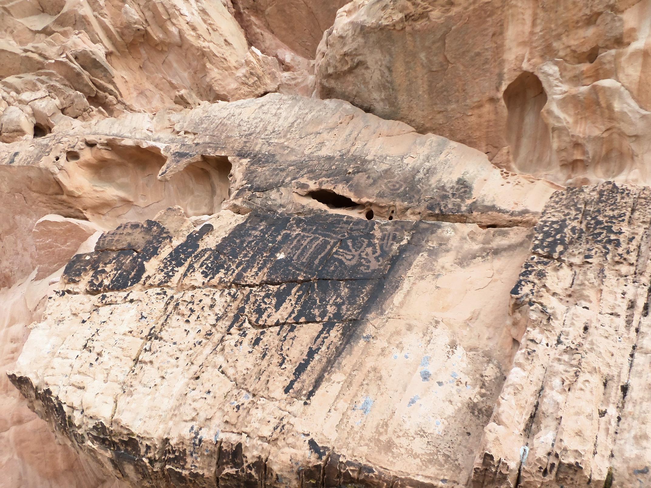
Petroglyphs at Whitey Pocket, Gold Butte area, NV – November 2014
My wife Deb and I left St. George about nine on a crisp late November morning. The first leg of the journey was simple—go south on Interstate 15 and drive approximately nine miles past Mesquite to Exit 112 (Riverside/Bunkerville exit). Take the exit and continue south crossing the Virgin River. Once across, the first intersection is Gold Butte Road. Turn right (west) at the intersection and set your trip odometer to 0. Gold Butte Road is paved, although not well maintained. The first five miles roughly parallel the Virgin River and take you past a melon farm. Stop along this stretch for nice photos of the meandering river. Later on you’ll see an oasis and at about 14 miles in catch a glimpse of Lake Mead to the west. At approximately 21 miles, and at the end of the paved road, the road forks. The now unpaved Gold Butte Road continues south. Take the unsigned left (east) fork variously named the Arizona Road and Whitney Pocket Road. The parking area, and also the trailhead, is about .3 miles from the fork. Park in a wide spot off the road on the left (north) side of the road.We parked and began exploring, there are no improved trails. From the parking area, walk east and you soon find a concrete water trough. Turn north into a small canyon to explore the 25 feet tall CCC built concrete dam to catch run-off water—very impressive.
Retracing our steps, we examined a large very red rock formation across the road. This formation included a stone room built out of a large pocket in the sandstone.
Directly east of the largest formation, another outcropping beckoned. Walking the perimeter we found one petroglyph panel. If you seriously explore this area, you will probably find others.

Strange rock erosion at Whitney Pocket, Gold Butte area, NV – November 2014
Everywhere we hiked the colors were striking. At several locations we availed ourselves to wonderful photos of red, yellowish, and white sandstone formations accented by Joshua Trees and framed by distant grey/brown mountains and white streaked blue sky. These vistas alone were worth the trip.
Along with great views, the eroded sandstone presented incredible formations—small arches and windows, cavities and deep fissures, competed with rock waves for our attention. All of this rising above the flat desert plain.
The weather was fine for a late November hike; temperature in the low 60s with some high wispy clouds. The elevation at the trailhead is slightly above 3,000 feet. Unless you do some serious rock climbing, there is little elevation change. We circumnavigated the three large outcroppings—about 2 ½ miles total in a little more than two hours. We expected to have the area to ourselves, and were surprised by several trailers and at least a couple dozen people. We met and chatted about desert wonders with two couples from Colorado.
I recommend this adventure combining natural beauty with some interesting artifacts. After exploring the wilderness, stop in Mesquite for a late lunch or early dinner. What could be better?
Tom Garrison is retired and enjoying libertarian life in beautiful St. George, Utah with his wife Deb and two cats. His latest book, Hiking Southwest Utah and Adjacent Areas, Volume 1 will soon be available at all e-stores. He may be contacted at tomgarrison98@yahoo.com


Love the picture on Facebook. It is so well framed and excellent composition. Wonder what a little shadow would do with sun coming from left or right is that is the way it comes up around there. It would be fun to play with even if is only come from top. However, it is great just the way it is. I and my wife have photographed all our lives. We are science teachers and rock hounds. Love the south west area and Valley of Fire when we discovered it about 25 years ago just blew our minds. We still go back when we can but it is getting so crowded especially after the articles written and the section of Star Trek movie filmed there it has brought a lot more visitors in. Have you been in the San Rafael Swell area of Utah yet? I am partially disabled now after retirement but still try to get out where I can. Best of luck with book, trips and photos.
Raymond:
Thanks for the kind words. My wife and I have been exploring the Southwest for about 25 years. The Valley of Fire is great. I wrote a published story about it (and many other places) so I may have contributed to the crowds. However, I try to encourage people to visit the great outdoors with minimal impact on the fragile desert ecosystem. We have yet to visit the San Rafael Swell. Our “to hike” list seems to grow instead of shrinking, even though we go on about 15 hikes per year.
Happy trails. Tom Garrison
My wife Gloria and I are lifetime member of the NHA Death Valley and have visited most of the parks in the West side of the Rockies and love the Desert areas. We have been to most of the major Native American reservations as we are keenly aware of their issues and problems. I am a small part NA myself and feel great kinship to all tribes and how badly they have been treated. Took some beautiful pictures down on the Zuni res. with a friend we made there and areas of the Dine res. also as we have friends there also. I am sure you know you need to check in and have a guide often on many of reservations. Do you have a list of the photo guides you have published, and where one can get them most easily. We have been teachers for about 35 years and both taught Outdoor environmental education our first 5 years of teaching. Keep up the good work.
Hey Raymond:
Deb and I have visited most national and state parks in the desert areas of California, Arizona, southern Nevada, and southwest Utah. They, and other public lands, are wonderful. We’ve not much been on Native American land, the big exception being Antelope Canyon in northeastern Arizona. That was amazing. I just had another hiking story published today. Here is the link:
http://www.thespectrum.com/story/life/outdoors/2014/12/10/little-black-mountain-baked-beans-petroglyphs/20208203/
In the past four years I’ve had more than 45 hiking stories published. The paperback version of my hiking book (with more than 50 color photos) can be found at:
http://www.amazon.com/Hiking-Southwest-Utah-Adjacent-Ares/dp/1503304841/ref=sr_1_1?s=books&ie=UTF8&qid=1418342693&sr=1-1&keywords=hiking+southwest+utah+and+adjacent+areas
It was just published and the ebook should be out in a couple of weeks.
I always love to receive comments from folks like you and your wife. I know you enjoy and work to preserve the outdoors. Good for you. Happy trails.
You two have really been on a lot of walks. I envy you the chance to walks much. I was in an accident 3 weeks before I retired and have been having troubles off and on since. We still get out when we can and usually head for souther Idaho fishing and then down ward till we get to Utah and often head to southern areas as far a Zuni reservation area. Go to where we can drive ( 4 X 4) most of the time and then hike out as much as we can from there. It has been a couple years since we have been out, but we are hoping to go this summer if all goes well. It is tough at times, especially now being 67.. We love looking for beautiful rocks to make into jewelry and have a small craft business we sell things we make at local craft fair near our home and have a good time at it. Have you done a lot of wandering the Capitol Reef NP area. There is a lot of splender in that park, including the littler used Notom road just at the east edge of the park going in and out till finally stays mostly on BLM land till you get down to Bullfrog at the edge of Lake Powell. Maybe we can share a few spots to check out and enjoy. We still do a lot with outdoor issues and groups, especially around home. Have a good winter and enjoy. Talk with you later, and will see if I can get one of your books. Thanks.